GNSS Receivers & Accessories
When the reference station has to be right for years, not just for the demo.
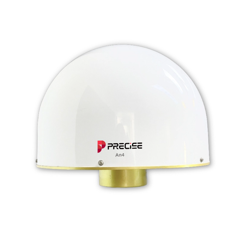
PRECISE AN4: Full-Band 3D Choke Ring GNSS Antenna. Phase center error ±1 mm | GPS, GLONASS, BDS, Galileo, QZSS, IRNSS + L-Band | IP67, MTBF > 30,000 hours | Φ379 × 312 mm, 9.3 kg bare
PRECISE AN4 is a full-band, 3D choke-ring GNSS antenna for high-grade reference stations and permanent installations where reflected-signal noise can't be tolerated. Where the compact AN2 suits space-constrained sites, AN4 is the choice when multipath suppression is the priority.
Challenge
Every error introduced at a reference station's antenna doesn't stay local: it propagates to every rover unit that depends on that base for corrections. On bridges, dams, ports, and CORS network points, the antenna sits in exactly the kind of environment that produces the worst multipath: metal structures, water surfaces, low-elevation obstructions, and nearby RF sources like power infrastructure and communication base stations. A reference station that degrades slowly over months of exposure is a harder problem to catch than one that fails outright.
Solution
AN4 uses a complete three-dimensional choke-ring structure with a four-feedpoint design to hold the phase center within ±1 mm of the geometric center, attenuating reflected signals from low elevation angles and the horizon. A 50 ± 2 dB LNA with out-of-band suppression adds further protection from nearby electromagnetic interference, in a fiberglass composite housing built for permanent outdoor deployment.
Value
The cleanest achievable signal at the reference station itself, so every connected rover inherits less noise, not more.
Key Benefits
Why AN4
±1 mm Phase Center Precision
±1 mm phase center stability
Reduces the systematic error a reference station would otherwise contribute to every baseline calculated from it, critical for deformation monitoring and geodetic networks.
±0mm
Phase Center Precision
A four-feedpoint design aligns the electrical and geometric centers (antenna-level spec; final accuracy depends on the full GNSS chain).
3D Choke-Ring Antenna Structure
Full 3D choke-ring multipath suppression
Meaningfully reduced reflection-driven noise on the sites where it matters most: bridges, dams, ports, and other challenging fixed installations.
The full 3D choke-ring structure attenuates ground, water, and structure reflections, especially at low elevation angles.
Full-Band Multi-Constellation Coverage
Full-band, multi-constellation, multi-frequency coverage including L-Band
Supports long-term network upgrades and multi-frequency processing without an antenna change as receiver capability grows.
Covers GPS L1/L2/L5, BDS B1I/B2I/B3I/B1C/B2a/B2b, GLONASS L1/L2/L3, Galileo E1/E5a/E5b/E6, QZSS L1/L2/L5/L6, IRNSS L1/L5, and L-Band.
IP67 Rugged Outdoor Construction
Built for permanent, unattended outdoor operation
Lowers lifecycle maintenance cost for reference stations expected to run for years without site visits.
IP0
Ingress Protection Rating
>0 hrs
MTBF Rating
Fiberglass composite construction, IP67, MTBF > 30,000 hours, and -40°C to +85°C operation (-55°C to +85°C storage).
Applications
Where It's Used
Customers
What Our Customers Are Saying
Carlos Rojas
Colombia
“Every rover on our CORS network depends on our reference antenna, and the AN4's ±1 mm phase center stability means we're not passing systematic error downstream. Our baseline results have never been more consistent.”
Elena Kovalenko
Ukraine
“We monitor a bridge next to a river, where water-surface reflections destroy weaker antennas. The AN4's full 3D choke-ring structure keeps our carrier-phase data clean even with the water right beside the site.”
Budi Santoso
Indonesia
“Our network keeps adding new receiver capability, and the AN4's full-band coverage across GPS, BDS, GLONASS, Galileo, QZSS, and L-Band means we haven't had to swap antennas as our system grows.”
Youssef Benali
Morocco
“Our reference stations sit in remote desert locations we can only visit a few times a year. The AN4's IP67 rating and 30,000-hour MTBF have kept every station running without an unplanned site visit.”
Technical Highlights
Engineered Detail
Complete 3D choke-ring structure with four-feedpoint phase-center design
±1 mm phase center error
Full-band coverage across six GNSS constellations plus L-Band
Up to 7 dBi gain with wide-beamwidth, low-elevation tracking
50 ± 2 dB LNA with out-of-band interference suppression
Fiberglass composite construction, IP67, MTBF > 30,000 hours
Technical Specifications
Full Spec Sheet
Antenna Performance
Low Noise Amplifier
Physical & Working Environment
How It Works
From Setup to Result
Suppress reflected signals while keeping the phase center aligned
The three-dimensional choke-ring structure and four-feedpoint design suppress reflected signals, especially from low elevation angles and the horizon, while keeping the phase center aligned to within ±1 mm of the geometric center.
Maintain tracking continuity in obstructed environments
High gain (up to 7 dBi) and wide beamwidth maintain satellite tracking continuity even in partially obstructed environments such as wooded or urban surroundings.
Filter interference before it degrades the signal
A 50 ± 2 dB low-noise amplifier with out-of-band suppression filters electromagnetic interference from power grids, telecom base stations, and radio transmitters before it can degrade the signal.
Pass the processed signal to the receiver
The processed signal passes through a TNC negative connector to the connected GNSS receiver, which performs the differential correction calculation distributed to rover units.
Run continuously, unattended, for years
The fiberglass composite, IP67-rated housing supports continuous unattended operation across a -40°C to +85°C range, with an MTBF rating above 30,000 hours.
FAQ
Common Questions
Because any phase-center instability, multipath, or signal noise introduced at the reference station propagates to every rover unit that depends on it for corrections. AN4's full 3D choke-ring structure is specifically engineered to minimize these error sources at the one point in the system where errors have the widest downstream impact.
No. This is an antenna-level phase-center specification. Final positioning results depend on the complete system (receiver, processing algorithm, baseline geometry, and site conditions), not the antenna in isolation.
GPS (L1/L2/L5), BDS (B1I/B2I/B3I/B1C/B2a/B2b), GLONASS (L1/L2/L3), Galileo (E1/E5a/E5b/E6), QZSS (L1/L2/L5/L6), IRNSS (L1/L5), and L-Band: full-band coverage for multi-system, multi-frequency reference station configurations.
IP67 dust and water protection, an MTBF exceeding 30,000 hours, and an operating range of -40°C to +85°C (storage -55°C to +85°C, 95% humidity without condensation), built for permanent, unattended outdoor deployment including high/low temperature, humidity, and salt spray exposure.
Choose based on site requirements, not on treating one as an upgrade of the other. AN4's full 3D choke-ring structure and ±1 mm phase-center stability suit high-grade fixed stations and extreme multipath environments (bridges, dams, ports, marine sites). AN2 is more compact (Φ180 × 180 mm, < 2.5 kg vs. AN4's Φ379 × 312 mm, 9.3 kg bare) and easier to deploy where installation space or weight is constrained, while still holding phase-center error under 2 mm.
A standard 5/8" × 11 teeth thread mount, with the antenna base installed pointing north for correct orientation, consistent with typical reference station pole, pillar, and tripod setups.
No. IP67 and the antenna's environmental rating protect the unit itself; they do not replace proper site grounding, surge protection, and lightning-rod design, which remain the installer's responsibility.
Get in Touch
Talk to PRECISE About AN4
Tell us about your project and we'll route it to the right PRECISE team.
- Sales: sales@precise-geo.com
- Support: support@precise-geo.com
Build Your Reference Station on a Signal You Don't Have to Second-Guess.
Talk to our team about matching AN4 to your site's multipath and environmental conditions.