
Machine Guidance
Dig Precisely. Work Independently. Finish with Confidence.
Centimeter-level bucket guidance for excavators: see your depth, your slope, and your target, live on screen, in any weather, on any major machine brand.
See It In Action
E2 in the Field
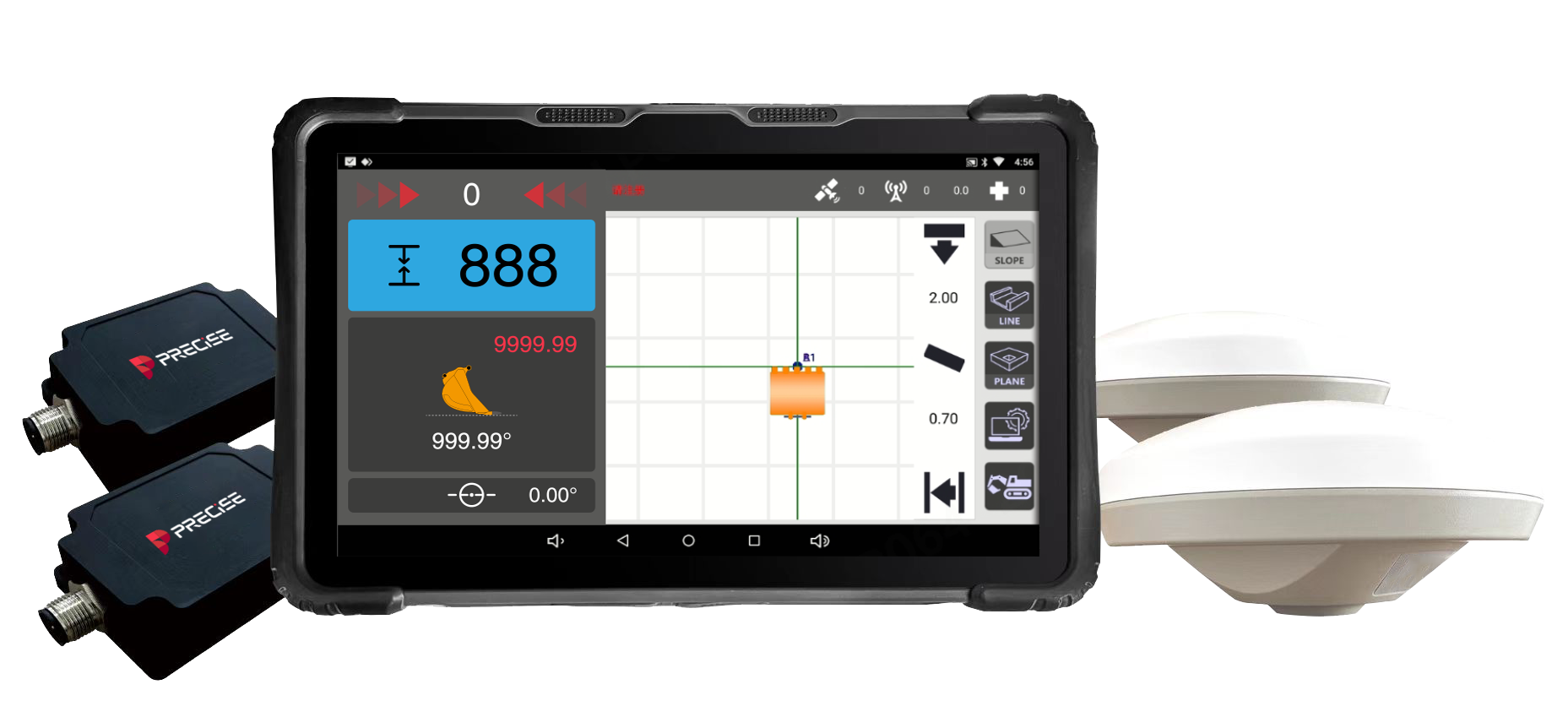
PRECISE E2 is a 3D excavator guidance system that senses the bucket's real-time position against the target grade and displays the deviation in-cab, so one operator can dig to design without a survey crew. E2 guides; it never drives the hydraulics or bucket.
Challenge
On most excavation sites, the operator can't see the design target, only the ground in front of the bucket. Checking depth or slope means stopping the machine and calling in a surveyor or stake crew, then repeating until it's right, which means idle machine time and a real risk of over- or under-digging when no one is available to check.
Solution
E2 combines dual GNSS positioning with dual IMU attitude sensing to calculate the bucket edge's real-time 3D position, then displays the live gap to the target elevation or slope on the in-cab touchscreen as the arm, boom, and bucket move.
Value
The operator sees the number on screen instead of waiting for someone else to measure, so there are fewer stoppages, less rework, and more consistent results across operators.
Key Benefits
Why E2
Dual GNSS-IMU Bucket Sensing
Real-Time Bucket Position and Grade Deviation
The operator always knows how much material is left to remove without stopping to call for a check.
Dual GNSS positioning and dual IMU sensing calculate the bucket edge's 3D position, showing the live deviation from the target depth, slope, or trench line.
Multi-View On-Screen Guidance
Multi-View Construction Guidance
Operators judge the target relationship faster and more intuitively, especially on slopes and trenches.
One-Operator In-Cab Guidance
One-Man Excavation, No Layout Crew
Frees up survey labor and removes the wait between "dig a bit" and "check the result."
Operator-Set RTK Reference Point
Reference-Based, Repeatable Operation
Every cut after that is measured against the same baseline, so results repeat across shifts and operators.
Applications
Where It's Used
Customers
What Our Customers Are Saying
Luis
Mexico
“We no longer need a survey crew on-site. Just me and the machine — that's it.”
Andi
Indonesia
“Once we set the reference point, everything else just flowed. Accurate and repeatable.”
Azman
Malaysia
“The setup was done in under 10 minutes. My team was shocked how easy it was.”
Marcelo
Brazil
“We installed it on four different excavators — all from different brands. No issues.”
Technical Highlights
Engineered Detail
Dual GNSS + Dual IMU for continuous bucket-position tracking through boom, arm, and bucket rotation.
All-constellation, multi-frequency GNSS tracking (BDS, GPS, GLONASS, Galileo, QZSS, SBAS) for stable fixes even in partially obstructed sites.
Built-in 4G dual-SIM and UHF radio (0.5W/1W/2W adjustable) so the system stays connected whether working with cellular correction services or a local base station.
IP67-rated hardware rated from -30°C to +75°C operating temperature for use across tunnels, wet sites, freezing mornings, and hot afternoons.
10.1" glove-friendly, sunlight-readable touchscreen for clear guidance display in direct sun or at night.
Modular, compact hardware designed for minimal cab intrusion and fast field installation or replacement.
Multi-mode support for trenching, slope work, and grading from the same unit.
Compatible with major excavator brands including CAT, Komatsu, and Hyundai, on both large and compact machines.

Technical Specifications
Full Spec Sheet
System Accuracy
Satellite Systems
Communication Configuration
Display and Control Terminal
Environmental Characteristics
Compatibility
How It Works
From Setup to Result
Set the Reference
The operator establishes an RTK reference point and enters the target depth, slope, or design line for the current task.
Sense the Machine
Dual GNSS antennas fix machine position and heading; dual IMU sensors on the boom, arm, and bucket track every rotation in real time, including movements that happen out of the operator's direct line of sight.
Calculate Bucket Position
The onboard system continuously combines GNSS and IMU data to compute the real-time 3D position and attitude of the bucket edge, with bucket dynamic attitude accuracy of 0.2°.
Display the Deviation
The 10.1" sunlight-readable touchscreen shows the live gap between the current bucket position and the design target, from multiple views, so the operator can adjust the next pass accordingly.
Dig to Grade
The operator uses the on-screen guidance to make corrections: E2 informs the decision, the operator executes it.
Watch & Learn
Setup, Features, and Unboxing
PRECISE E2 Unboxing Video
FAQ
Common Questions
E2 is a guidance system, not an automatic control system. It does not move the bucket or control the hydraulics. It continuously shows the operator the real-time gap between the bucket's position and the design target (depth, slope, or trench line), and the operator makes every cut manually based on that information.
E2 delivers ±1.5 cm horizontal and ±3 cm elevation accuracy under normal RTK operating conditions, with a bucket dynamic attitude accuracy of 0.2°. Actual results depend on correct reference-point setup, satellite visibility, and site conditions.
E2 is designed to mount on most mainstream excavators, including CAT, Komatsu, and Hyundai models, in both large and compact size classes.
E2 has built-in dual-SIM 4G and an adjustable-power UHF radio (0.5 W / 1 W / 2 W, 410–470 MHz), so it can receive RTK corrections via cellular network or a local base station without extra external modules. Bluetooth 4.2 and Wi-Fi are also built in for diagnostics and updates.
Yes. The hardware is IP67-rated and rated for operation from -30°C to +75°C, and storage from -40°C to +85°C, suitable for tunnels, wet sites, freezing mornings, and hot afternoons.
E2 uses modular hardware and a guided calibration process designed to get the system operational without specialized equipment. Typical setup time is under 10 minutes for a crew already familiar with the process, based on PRECISE installation testing; actual time depends on the machine and installation conditions.
E2 supports multiple work modes for trenching, slope trimming, channel clearing, and fine grading, so operators can switch between tasks on the same machine without additional hardware.
Get in Touch
Talk to PRECISE About E2
Tell us about your project and we'll route it to the right PRECISE team.
- Sales: sales@precise-geo.com
- Support: support@precise-geo.com
Take the Leap to Superior Accuracy. Get Your PRECISE E2 Today!
Unlock precision and efficiency with PRECISE. Order now, or contact our sales team to discuss your fleet.